Why do we call it a world war?
Before you shrink this war down to Europe.
Almost everything you will see about this war — the trenches, the mud, the poppies — is in one corner of one continent. That corner matters. But it is not the whole thing, and if you start there you will spend the rest of the unit quietly believing this was a European war that a few other places joined.
It was not. So look at the whole planet first.
If you have already done the Europe 1914 map task: you spotted something odd along the bottom edge — Algeria, Tunisia and Morocco marked as French, three places not in Europe at all, on a map of Europe. This is the task that follows that hint up.
Part A · Read the map: who was in it?
Do not write anything yet. Just look for thirty seconds.
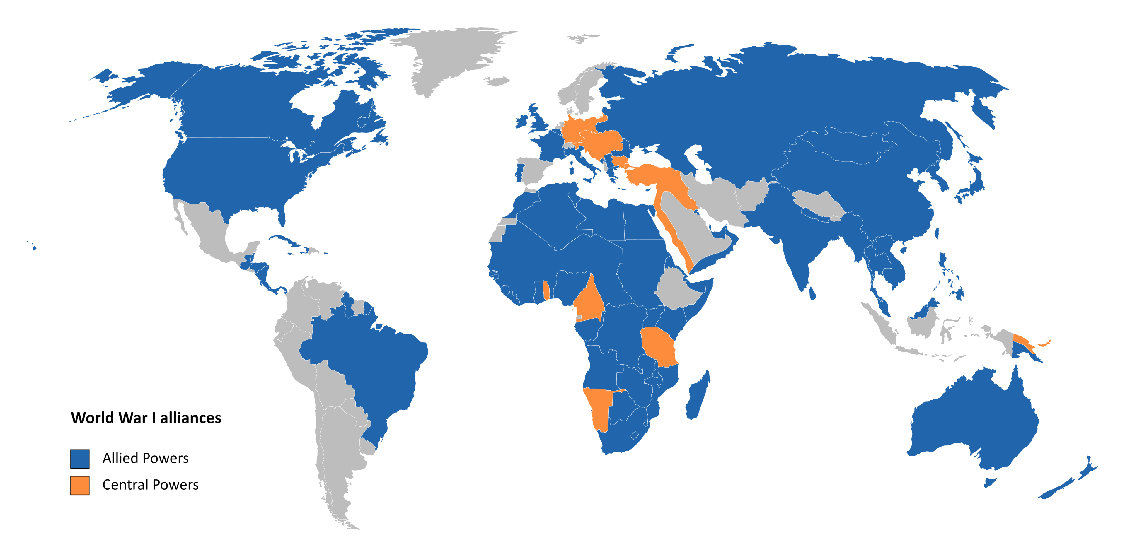
Now answer in short sentences:
- Roughly what fraction of the world is coloured in — a quarter, a half, most of it?
- Name two places outside Europe that are blue.
- Find the grey countries. Grey means neither side. Name two.
The question this map should make you ask
Look at Africa. Almost the whole continent is coloured.
So — did all those countries hold a meeting and choose a side?
No. In 1914 most of Africa was ruled by European empires. When Britain and France went to war, everything Britain and France ruled went to war with them. Nobody asked the people who lived there. The map colours them in because of who governed them, not because of what they decided.
That is the real answer to “why is it called a world war”: the empires were already worldwide before the war started. The war did not spread across the globe so much as the globe was already tied together, and the war ran along the ties.
Write one sentence: what does this map show you that a map of Europe cannot?
Part B · Mark your world map
On the blank map your kaiako gives you. Make a legend in a corner as you go.
- First, before anything else: find Aotearoa New Zealand and mark it. Write “we are here”. It is the pair of long islands low down, right of Australia.
- Mark the Western Front — northern France and Belgium. New Zealand soldiers were there from 1916.
- Mark the Eastern Front — the long front between Germany/Austria-Hungary and the Russian Empire.
- Mark Gallipoli — on the Ottoman coast, where New Zealand and Australian troops landed in April 1915.
- Mark German Samoa. See the note below — you will not be able to spot it on your own.
- Mark the Middle East — there was fighting across Ottoman territory, well beyond the Dardanelles.
- On the reference map above, find the orange patches inside Africa. Those were German colonies, and there was fighting in Africa too. Mark roughly where they are.
- Shade the oceans between your marks. Everything — soldiers, food, weapons, letters — moved by sea. The sea is not the empty part of this map; it is the part that made the rest possible.
- Draw a line from Aotearoa to Gallipoli. That is how far a New Zealand soldier travelled to get there.
About Samoa: on a map of the whole world, Samoa is about two millimetres across. It is on your map — a speck up and to the right of Aotearoa — but you will not find it by looking. Your kaiako will point to it. Mark it with a dot and label it, and make the dot bigger than the island.
That is worth a moment's thought on its own. A world map is a set of decisions about what is big enough to draw. Being too small to appear on the map did not stop Samoa mattering — as you are about to see.
Part C · The New Zealand thread
Here is how fast this reached us.
- 4 August 1914 — Britain declares war on Germany
- New Zealand was part of the British Empire. Britain's declaration applied to New Zealand too. No separate New Zealand decision was needed for us to be at war.
- 29 August 1914 — New Zealand forces occupy German Samoa
- Twenty-five days later. New Zealand troops took a German colony in the Pacific. On your map, that is the dot you just made.
- April 1915 — Gallipoli
- New Zealand and Australian troops land on the Ottoman coast, on the other side of the world.
- 1916 — the Western Front
- The New Zealand Division is in France and Belgium.
The hard question — and it is the unit's question, not a side note
New Zealand was at war because Britain was. But sending a force to take another country's colony within a month was a choice, and somebody here made it.
So which is it? Choose one, and justify it with something you can actually point at:
- New Zealand was mostly a follower, doing what the Empire required
- New Zealand was an active imperial participant, taking territory of its own
- Evidence of both
Keep this answer. We come back to Samoa after the war — because New Zealand did not hand it back. New Zealand governed Samoa afterwards, and what happened there under New Zealand's administration is part of this unit.
Part D · Finish the sentence
You wrote the start of this in your orientation sheet. Now finish it with the world map in front of you.
“It became a world war because…”
Challenge · whose map is this?
Only once Parts A–D are done.
You used two world maps today. One put Europe near the middle. One put the Pacific in the middle — so Aotearoa is near the centre and Europe is squeezed against the left edge.
Neither is wrong. A round planet has no edge. Somebody chose where to cut it.
Which map made this war look like it was mostly about Europe? Why?
If you grew up in Apia, or in Cairo, or in Kolkata, which map would you rather be handed — and what would you want it to show that neither of these does?
Kaiako notes
- Runs in either position, and the unit wants it first. Week 1's micro-learning moves list the sequence as “World scale → Europe → Balkans”, and this is the world-scale artefact that step needed. Run it before the Europe 1914 map task to follow the unit's own order — or after it, where it answers the exact question that task closes on (“this is called a world war; what does a map of Europe alone hide about that?”). The opening paragraph is written to work both ways.
- You must point to Samoa. Verified on the actual file: Samoa is drawn, but it is about 70 pixels across on a 2440px map — roughly 2mm on A4. Students cannot find it unaided, and the task text tells them so rather than pretending otherwise. It sits up and to the right of Aotearoa, a little past Fiji. Point to it on the projected blank and have them mark from that.
- The blank is Pacific-centred on purpose. Every Europe-centred world map cuts the Pacific at the edge and drops Samoa off the sheet — unusable for this unit. The side effect is that the Western Front and Gallipoli sit in the squeezed left-hand portion; they are markable, but if you want European detail, use the Europe 1914 map task instead. That division of labour is the point: one map for the theatre, one for the globe.
- Both maps use modern borders. Say so once, out loud. The task only ever asks pupils to mark places and theatres, never to read a border as a 1914 border — the 1914 borders are the Europe map's job.
- The Africa question in Part A is the heart of the lesson, not an extension. If the period is short, cut the Eastern Front and Middle East marks before you cut that box. “The empires were already worldwide” is the idea that makes “world war” mean something other than “a big war”.
- Part C uses the unit's own framing (follower / active imperial participant / both) so it feeds straight into the Identity Evidence Ledger rather than competing with it. The dates are the unit's dates.
- Do not resolve the Samoa question for them. “Evidence of both” is a perfectly strong answer when it is justified. The point is that they have taken a position they will have to revisit when the unit returns to Samoa after the war.
- Print in landscape. A3 if your copier allows — the Pacific blank is wide, and at A4 portrait the theatres get cramped.
- Going further: NZHistory's interactive First World War map is the best follow-up if you have devices — it is built for exactly this “where in the world” beat.