Europe 1914 · build the map first
Before you start: where and when are we?
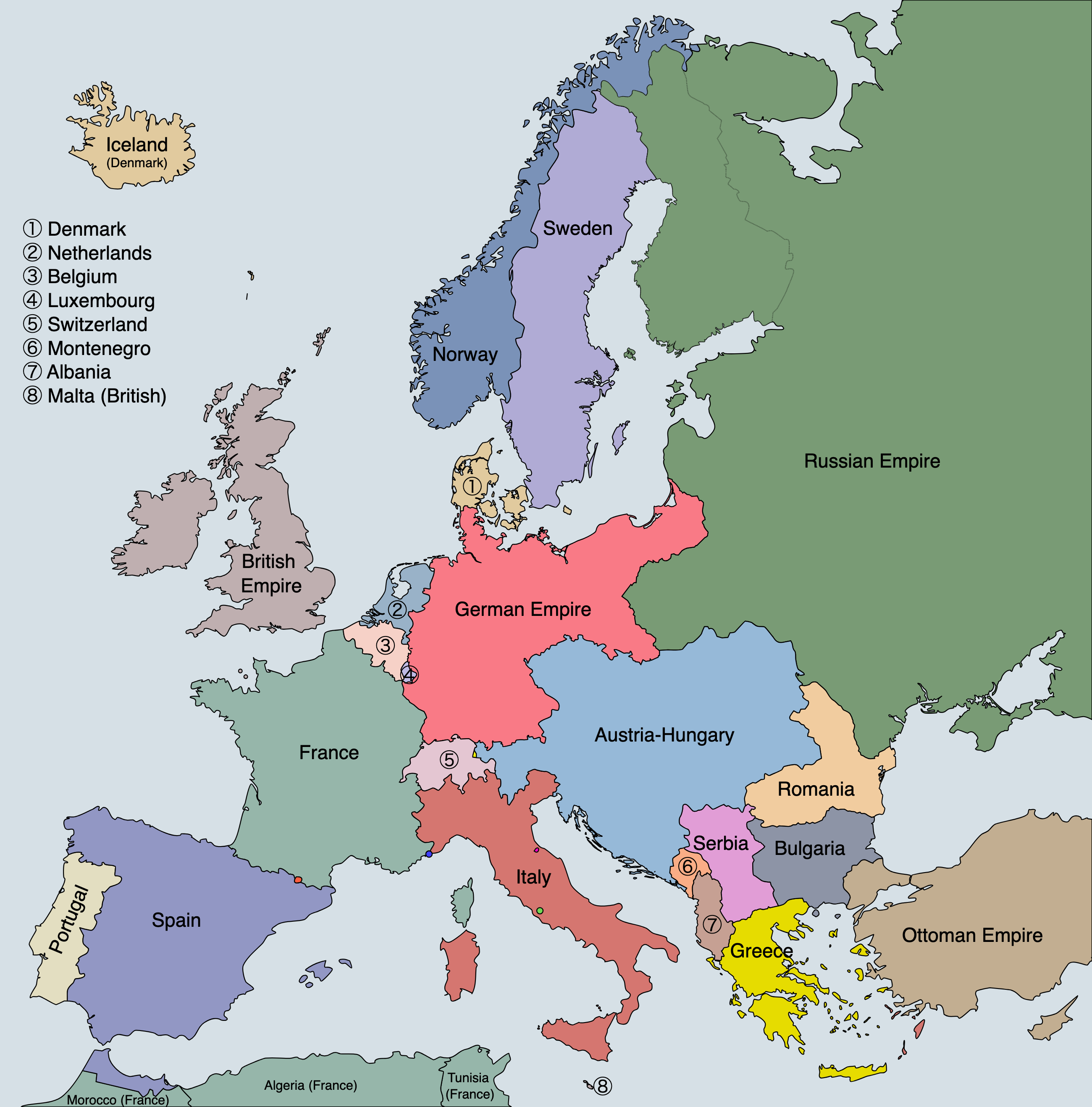
This is Europe in 1914 — about 110 years ago. Some of the countries on this map do not exist any more. Some have different names or different borders today. That is not a mistake on the map. Borders change, and working out how and why they changed is a large part of what history is.
You are not expected to already know this geography. Learning where these places are is part of learning the history, not something you should have arrived with.
The reference map
Keep this beside you for the whole task. Every country has its own colour. The colours do not tell you who was on whose side — working that out is your job in Part B.
Part A · Find the places
Use the reference map. Point to each place with your finger before you write anything.
- Britain / United Kingdom — labelled “British Empire” on this map
- France
- German Empire
- Austria-Hungary
- Russian Empire
- Serbia
- Ottoman Empire
- Belgium — small; find ③ in the key
- Italy
Pause: what is Austria-Hungary?
Find the big pale-blue one in the middle of the map. That is Austria-Hungary — and it is probably the single most important thing on this map that you have never heard of.
It was a multi-national empire: one state containing many different peoples speaking many different languages. It is not on a map today. It broke apart at the end of this war.
The land that was Austria-Hungary in 1914 is today shared between Austria, Hungary, Czechia, Slovakia, Slovenia, Croatia and Bosnia and Herzegovina, plus parts of Poland, Romania, Serbia, Montenegro, Ukraine and Italy. That is twelve or more of today's countries inside one 1914 state.
On your reference map: trace Austria-Hungary's border with your finger. Then find Serbia — the small pink country on its southern edge.
Pause: what is an empire?
An empire holds many peoples, territories and languages under one political authority. Three on this map say so in their own names: Austria-Hungary, the Russian Empire and the Ottoman Empire.
Britain and France were empires too — but most of what they ruled is not on this map at all. Look at the very bottom: Algeria, Tunisia and Morocco are marked as French. That is a hint about how much a Europe-only map leaves out. Hold on to that; it comes back at the end.
Part B · Colour your blank map
On the blank map your kaiako gives you:
- Create a legend / key in the corner.
- Colour the main Allied / Entente powers one colour.
- Colour the main Central Powers another colour.
- Mark countries that were neutral, or not yet on that side at the date you have chosen, differently — do not force every country onto a team.
- Label the countries from Part A.
- Circle Serbia.
Part C · Check and correct
When the answer map goes up on the board:
- Do not erase your mistakes.
- Correct them with a second colour, a symbol, or a note in the margin.
- Put a star beside one place you did not know before today.
A corrected map is better evidence of learning than a clean one. The corrections are the part that shows your thinking.
My new place was: ______________________________
I had it wrong because:
Part D · Zoom in: the Balkans
Now look closely at the corner of Europe where the war actually started.
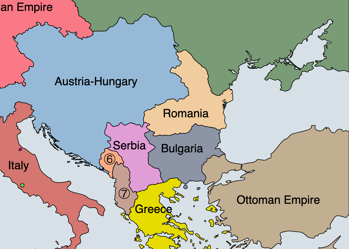
Find each of these on the detail map:
- Austria-Hungary (pale blue)
- Serbia (pink)
- the Ottoman Empire (brown, to the south-east)
- the Russian Empire (green, top right corner)
Where is Sarajevo — and why does it matter?
In June 1914 Archduke Franz Ferdinand of Austria-Hungary was shot in the city of Sarajevo. Sarajevo is in Bosnia.
Here is the part almost everyone gets wrong: in 1914 Bosnia was part of Austria-Hungary, annexed in 1908. On the detail map, follow Austria-Hungary's pale blue down the Adriatic coast, west of Serbia — that stretch is Bosnia.
So the Archduke was killed inside his own empire, not in Serbia. The man who shot him was a Bosnian Serb — a Serb living under Austria-Hungary's rule.
Why this matters: “Serbia killed the Archduke, so Austria-Hungary attacked Serbia” is the version most people carry, and it is too simple to be true. Keep that in mind when you get to causation.
Answer in short sentences:
- Which large empire borders Serbia?
- Which other major power might take an interest in Serbia?
- Why could a crisis here pull in countries far larger than Serbia?
Quick retrieval before MAIN
Cover the reference map. Can you now:
- point roughly to Germany?
- point roughly to Austria-Hungary?
- find Serbia?
- name one country on each main side?
If not, uncover the map and go again. You are not behind — you are doing the part everyone has to do.
Challenge · a map is a source too
Only once the core map is secure:
What does this map make easy to see?
This is called a world war. What does a map of Europe alone hide about that? (Look again at the bottom edge — and think about where else Britain and France ruled.)
When you have written your answer, go and test it: Why do we call it a world war? → That task hands you the world map this one cannot show you.
Compare with Europe today: name one country on this map that no longer exists, and one that has a different name now.
Kaiako notes
- Print the blank at A3 if you can. A4 works, but Belgium, Serbia, Montenegro and Albania get very small for colouring. The blank is an SVG, so it stays sharp at any size.
- The blank has been recoloured from the original grey-fill version to white fill with dark borders — it takes pencil and costs far less toner for a class set.
- The reference map is deliberately not coloured by alliance. Each state has its own colour, so Part B stays a thinking task rather than a copying task.
- The reference map labels the UK as “British Empire”; Part A names it “Britain / United Kingdom”. Worth one sentence out loud — and it previews the empire point.
- Answer map for Part C: project the reference map and build the alliance colouring live with the class, rather than revealing a finished answer. The mistakes are the lesson.
- The Sarajevo box is the highest-value correction in this task. Most textbooks compress it, and pupils arrive with “Serbia shot the Archduke”. Getting Bosnia's status right in Week 1 pays off in Week 4 when contested loyalty comes up.